Precision-Crafted charts
Built with detail to ensure flight accuracy.
From over 100 reviews

Pilot's KnowHow right at your fingertips
We display exactly what a pilot needs - not more, not less…
With our charts and the displayed aeronautical knowhow long-haul pilots of airlines and business jets fly across the globe and we make your work up there easier with the information we display right at your fingertips.


Our extensive chart library includes worldwide coverage. All daily updated and quality-controlled.
Stay ahead with charts that integrate daily-updated NOTAMs directly into airport symbols – covering runway availability, closures, and temporary changes.
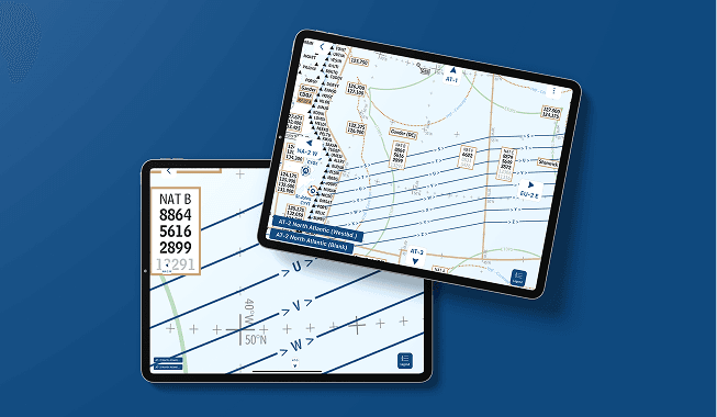
Get the latest NAT-Tracks and PACOT-Tracks for optimal routing, along with embedded text boxes featuring real pilot insights, emergency procedures, and operational tips.
Replacing your NAT Plotting Chart for easy NAT crossing.
Every detail is curated and updated with a pilot’s mindset – because we fly like you do.

Charts focus on critical data such as airport usability, runway directions, landing capabilities, and suitability for medical emergencies.

All charts are refreshed daily at 00:30Z, with NAT- & PACOT-Tracks updated 15 minutes after new tracks are published.

Key chart boxes for NAT, R/T, Africa IFBP, Shanwick, Kabul, in-flight, and emergency procedures - everything pilots need in one place.

Our free PlanningCharts App is available for iOS, Android and Windows, allowing users to access and update charts conveniently, even offline.


At PlanningCharts, we deliver aviation charts with unmatched clarity, accuracy, and ease of use - trusted by professionals to ensure safe, efficient flights.
Built with detail to ensure flight accuracy.
Made for pilots. Easy to read. Always current.
Trusted by pilots worldwide for consistent, reliable data.
Smarter flight preparation through detailed and updated charts.
Your charts were the best and I always found them very useful on all my flights.
The charts are incredibly well-designed, delivering exactly the information professional pilots need at a glance. With their clear layout and operational focus, they make flight preparation faster, easier, and more reliable.
I have been using these charts on and off since Gerd Puppel started posting them. I now mainly use them during route training or heavy crew rotation for an improved situational awareness. I have taken a year's subscription for the charts, there is a lot of potential in your project.
I've enjoyed your charts for many years for free. Happy to provide some compensation for the demanding work and valuable tools.
I‘m currently flying in the middle east and I just got the chance to use one of your charts (provided by a colleague and costumer of yours) on a flight to Auckland! The chart helped us a lot with the HF frequencies down there in Brisbane and Melbourne! I loved the presentation, the information and how often you updated!
I downloaded your charts yesterday before my LAX-LHR sector and I have to say that I found them a great tool for improving situational awareness, with the information presented in a simple to interpret format. They are a bit like our old paper flight progress charts but with the bonus of being updated daily and with the NAT tracks overlaid. I found myself referring to your charts more often than to the official enroute map.
Beautifully simplified charts with all the essentials — no distractions, just pure usability. Ideal for efficient planning of my north atlantic flights.
